weather radar map
The science of weather forecasting has evolved dramatically over the past century, with weather and radar technology playing a pivotal role in how we predict and prepare for atmospheric changes. From tracking storms to anticipating clear skies, weather radar systems have become indispensable tools for meteorologists, emergency responders, and even the general public. By providing real-time data through tools like the weather radar map, these systems allow us to visualize and interpret weather patterns with unprecedented accuracy. This article explores the mechanics, applications, and future of weather radar technology, shedding light on its critical role in modern meteorology.
The Basics of Weather Radar
At its core, weather radar—short for radio detection and ranging—operates by emitting radio waves that bounce off objects in the atmosphere, such as raindrops, snowflakes, or even birds. When these waves return to the radar, they provide data about the location, intensity, and movement of weather systems. This process, known as Doppler radar, is the backbone of modern weather forecasting. By analyzing the frequency shift of returning waves, meteorologists can determine the speed and direction of weather phenomena, such as storms or wind patterns.
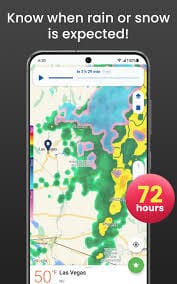
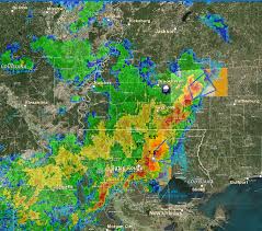
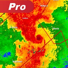
The data collected by radar systems is typically displayed on a weather radar map, which offers a visual representation of precipitation across a specific region. These maps use color gradients—often green for light rain, yellow for moderate, and red for heavy precipitation—to indicate the intensity of weather events. For the average person, these maps are accessible through apps, websites, or television broadcasts, providing a quick snapshot of what to expect outdoors.
How Weather Radar Works
To understand the significance of weather and radar, it’s essential to grasp how radar systems function. A weather radar consists of a transmitter that sends out pulses of electromagnetic energy and a receiver that captures the reflected signals. These signals are then processed to create detailed images of atmospheric conditions. The radar’s antenna rotates to scan a wide area, often covering hundreds of miles, allowing meteorologists to monitor weather systems in real time.
Doppler radar, a key advancement in weather radar technology, measures not only the location of precipitation but also its velocity. This capability is crucial for identifying severe weather events, such as tornadoes, where rapidly rotating winds can be detected through changes in the radar signal. By combining data from multiple radar stations, meteorologists can create comprehensive weather radar maps that provide a regional or even national view of weather patterns.
Applications of Weather Radar
The applications of weather radar extend far beyond daily forecasts. In aviation, radar data helps pilots navigate around turbulent weather, ensuring safer flights. In agriculture, farmers rely on weather radar maps to plan planting and harvesting schedules, minimizing the risk of crop damage from unexpected storms. Emergency management agencies use radar to issue timely warnings for hurricanes, tornadoes, and flash floods, potentially saving lives.
For the public, weather and radar technology has democratized access to weather information. Smartphone apps like AccuWeather or Weather Underground provide real-time weather radar maps, allowing users to track storms as they approach their location. This accessibility empowers individuals to make informed decisions, whether it’s canceling a picnic or preparing for a severe storm.
The Evolution of Weather Radar Technology
The history of weather radar dates back to World War II, when military radar systems were repurposed to detect precipitation. Early systems were rudimentary, capable of identifying only the presence of rain or snow. However, advancements in computing and signal processing have transformed radar into a sophisticated tool for weather analysis. Modern systems, such as the National Weather Service’s NEXRAD (Next-Generation Radar), provide high-resolution data that can detect even small-scale weather phenomena, like microbursts or hail.
The integration of weather and radar data with other technologies, such as satellite imagery and computer modeling, has further enhanced forecasting accuracy. Satellites provide a broader view of global weather patterns, while radar focuses on localized events. Together, they create a comprehensive picture that meteorologists use to predict everything from daily temperatures to catastrophic hurricanes.
Challenges in Weather Radar Interpretation
Despite its advancements, weather radar is not without limitations. One challenge is radar beam blockage, where terrain features like mountains or buildings obstruct the radar signal, creating gaps in coverage. Another issue is ground clutter, where non-weather objects like trees or structures reflect radar waves, leading to false positives on weather radar maps. Meteorologists must carefully filter this noise to ensure accurate interpretations.
Additionally, radar systems are less effective at detecting certain types of precipitation, such as light drizzle or snow, which may not reflect radio waves as strongly as heavy rain. To address these challenges, scientists are developing dual-polarization radar, which uses both horizontal and vertical pulses to provide more detailed information about precipitation type and size. This technology is improving the accuracy of weather radar maps, particularly for identifying severe weather threats.
The Role of Weather Radar Maps in Everyday Life
For most people, the weather radar map is the most tangible connection to radar technology. These maps are widely available through media outlets, websites, and mobile apps, offering real-time updates on precipitation and storm movement. By checking a weather radar map, you can see whether a storm is heading toward your area or if clear skies are on the horizon. This information is invaluable for planning outdoor activities, commuting, or preparing for severe weather.
Public access to weather and radar data has also fostered a greater understanding of meteorology. Amateur weather enthusiasts, often called storm chasers, use weather radar maps to track storms and document phenomena like tornadoes or thunderstorms. These citizen scientists contribute valuable data to the meteorological community, further bridging the gap between professional forecasting and public engagement.
The Future of Weather Radar
As technology advances, the future of weather radar looks promising. Researchers are exploring ways to improve radar resolution, allowing for more precise detection of small-scale weather events. Artificial intelligence and machine learning are also being integrated into weather and radar systems to enhance data analysis and prediction accuracy. For example, AI algorithms can identify patterns in radar data that might indicate the formation of a tornado, enabling earlier warnings.
Another exciting development is the use of phased-array radar, which offers faster scanning and more detailed data than traditional systems. This technology could revolutionize weather radar maps, providing even more granular information about storm structure and movement. Additionally, efforts are underway to make radar systems more energy-efficient and portable, enabling their use in remote or underserved areas.
Conclusion
The interplay of weather and radar has transformed how we understand and respond to atmospheric conditions. From the detailed imagery of weather radar maps to the life-saving warnings issued during severe storms, weather radar technology is a cornerstone of modern meteorology. As advancements continue to refine its capabilities, radar will play an even greater role in helping us navigate the complexities of weather. Whether you’re a farmer, a pilot, or simply someone checking the forecast, the impact of weather radar is undeniable, shaping our relationship with the skies above.